GP3.2 Weather Forecast (en): Unterschied zwischen den Versionen
Zur Navigation springen
Zur Suche springen
Mfgeg (Diskussion | Beiträge) |
|||
| (10 dazwischenliegende Versionen von 2 Benutzern werden nicht angezeigt) | |||
| Zeile 3: | Zeile 3: | ||
|[[Bild:english.png]] - [[GP3.2 Weather Forecast (en)|in English]] | |[[Bild:english.png]] - [[GP3.2 Weather Forecast (en)|in English]] | ||
|} | |} | ||
| − | [[Datei:GP3.2 Wettervorhersage.png|right|thumb|400px| | + | {{Achtung|As of '''GP3.2''' - <code>'''0.81-r1'''</code> and '''GP3.3''' - <code>'''0.83-r2.10'''</code> the embedded weather forecast is no longer available.}} |
| − | + | [[Datei:GP3.2 Wettervorhersage.png|right|thumb|400px|Weather forecast]] | |
| + | Since GP3.2 Version <code>v0.79</code> a weather forecast is integrated in the Blue Panel by default. The weather data is provided by [http://openweathermap.org/ OpenWeatherMap]. The Plugin has following features: | ||
| − | * ( | + | * (configurable) forecast up to 14 days |
| − | * | + | * Multiple cities configurable |
| − | * | + | * Configurable display (e.g. clouds, wind, pressure, lunar phases, etc.) |
| − | * | + | * Display of maps (e.g. snow, rain, wind, etc.), browser is required |
| − | * | + | * Language can be set independent from the system language |
| + | * Temperature graph of the selected city | ||
| + | * Setting to choose which temperature schould be displayed first, day or night | ||
| + | * The selected city can be opened in [[GP3.2 Google Maps (en)|Google Maps]], if installed | ||
| − | == | + | == Usage == |
| − | + | After opening the weather forecast, following features are avvailable. | |
{| class="wikitable" border="1" | {| class="wikitable" border="1" | ||
| − | ! width="80px" | ''' | + | ! width="80px" | '''Button''' |
| − | ! width="600px" | ''' | + | ! width="600px" | '''description''' |
|- | |- | ||
| − | | width="70px" | {{Red| | + | | width="70px" | {{Red|Update}} |
| − | | width="600px" | | + | | width="600px" | Update of the weather data, for the selected city. |
|- | |- | ||
| − | | width="70px" | {{Green| | + | | width="70px" | {{Green|Cities}} |
| − | | width="600px" | | + | | width="600px" | Possibility to configure, edit, delete the desired cities. |
| + | |- | ||
| + | | width="70px" | {{blue|Temperature}} | ||
| + | | width="600px" | Temperature graph of the selected city. | ||
|- | |- | ||
| width="70px" | {{Taste|MENU}} | | width="70px" | {{Taste|MENU}} | ||
| − | | width="600px" | | + | | width="600px" | To select the different maps (e.g. precipitation, temperature, etc.) which can be opened in the browser. |
| − | + | It's also possible to access the settings. There you can enable or disable different views, and set the desired language. | |
|} | |} | ||
== Screenshots == | == Screenshots == | ||
<gallery> | <gallery> | ||
| − | Datei:GP3.2 Wettervorhersage Stadt.png| | + | Datei:GP3.2 Wettervorhersage Stadt.png|City configuration |
| − | Datei:GP3.2 Wettervorhersage Einstellungen.png| | + | Datei:GP3.2 Wettervorhersage Menu.png|Map selection |
| − | Datei:GP3.2 Wettervorhersage Temp Karte.png| | + | Datei:GP3.2 Wettervorhersage Einstellungen.png|Settings |
| + | Datei:GP3.2 Wettervorhersage Temp Karte.png|Temperature map | ||
| + | Datei:GP3.2 Wettervorhersage Temperaturgrafik.png|Temperature graph | ||
</gallery> | </gallery> | ||
| − | == | + | == Configuration file == |
| − | + | The settings for the plugins are stored in the <code>gweatherlist.json</code> file, in the directory <code>weather</code> of the [[GP3_general_settings_(en)#Path_for_Gemini-Cache|Gemini Cache]]. | |
| − | [[ | + | [[Kategorie:GP3 (en)]] |
Aktuelle Version vom 16. April 2016, 11:43 Uhr
As of GP3.2 - 0.81-r1 and GP3.3 - 0.83-r2.10 the embedded weather forecast is no longer available.
|
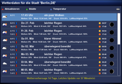
Since GP3.2 Version v0.79 a weather forecast is integrated in the Blue Panel by default. The weather data is provided by OpenWeatherMap. The Plugin has following features:
- (configurable) forecast up to 14 days
- Multiple cities configurable
- Configurable display (e.g. clouds, wind, pressure, lunar phases, etc.)
- Display of maps (e.g. snow, rain, wind, etc.), browser is required
- Language can be set independent from the system language
- Temperature graph of the selected city
- Setting to choose which temperature schould be displayed first, day or night
- The selected city can be opened in Google Maps, if installed
Usage
After opening the weather forecast, following features are avvailable.
| Button | description |
|---|---|
| Update | Update of the weather data, for the selected city. |
| Cities | Possibility to configure, edit, delete the desired cities. |
| Temperature | Temperature graph of the selected city. |
| MENU | To select the different maps (e.g. precipitation, temperature, etc.) which can be opened in the browser.
It's also possible to access the settings. There you can enable or disable different views, and set the desired language. |
Screenshots
Configuration file
The settings for the plugins are stored in the gweatherlist.json file, in the directory weather of the Gemini Cache.


